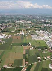
![Map of the Rometta area divided in lots - CLICK FOR THE AREA PLANIMETRY [.pdf 1.128 kb]](../img/map_rometta3.jpg) Rometta Production Area
Rometta Production Area
The Rometta area has been conceived as a specific centre for logistics and middle and large industries.
Designed with totally innovative features of urban compatibility, it is located south-east of the Cittadella territory, on the boundary with the town of Tombolo.
It covers a 528,515 sq. m. area and is divided in 49 lots.
The lots will be equipped with all the necessary underservices and connected to the various mains (see below).
The lots overlooking the built-up area will be provided with a 10 m green belt. The total green surface will be 30,367 square metres.
The road system has been designed so that it will not interfere with that of the town. The main road has a 15m cross section with two lanes for each direction (3.75 m each one), including pavements, bicycle paths and parking or emergency lanes on both sides. The roads within the area have a 15.50 m cross section, as well as pavements and parking or emergency lanes on both sides.
Besides the parking places on the sides of the roads, there are six more car park areas covering a 35,054 sq. m. total surface.
At each factory
- Electricity mains
- Drainage mains
- Water mains
- Telephone lines
- Fibre optic
- Gas mains
Most enterprises which have applied for the lots so far carry out their activities in the field of mechanics, thermohydraulics, carpentry, logistics, production of varnishes and paints and commerce of timber.